
Karl Gotsch
Translation by Google, Needs Editing
From the Website of Karl Gotsch
Posted with permission of the author, February 21, 2021
![]()
Preliminary remark
My father was born in the village of Jakobeny in Romania. My grandparents and great-grandparents were also born in this place and spent their entire lives there, or at least most of them. If, despite this birthplace, German was spoken in our family by no means Romanian, there is a special reason. This special reason is the Zipser country team, to which my paternal ancestors belonged, combined with their special history. It is therefore important to first report on the history of the Spiš Germans.
The Spiš and the origins of their settlement
The German name Zips can hardly be found on today’s maps. This is the Slovak basin landscape southeast of the High Tatras, which has been called Spis in Slovak since 1945. A further step back into the 12th century is to be made. The Hungarian kings were about to consolidate their kingdom. The administration was reorganized and craftsmen and farmers were called into the country. In order to be able to mine the rich natural resources, the Hungarian kings Ladislaus and Geisa II called German settlers and miners into their empire. These settlers came from southern Germany, Silesia and the Flemish areas. Some of these colonists were given the upper Hungarian mining area in the south-east of the High Tatras in the Szepes County (administrative district), in German Zips, assigned. The most important 24 cities in this area, at the top Leutschau, Käsmark and Göllnitz, received extensive privileges. By free letters in 1271, which were confirmed by King Ludwig the Great (1326-1382), these cities received the status of a free city. They were no longer subordinate to the clerk, but directly to the king. Due to the predominant colonization of this area by Germans and their administrative independence, a German language island developed in the middle of the Slavic environment, which was consolidated in the form of the language and lasted for several centuries. This Zipser German was also the language of my grandparents. which were confirmed by King Ludwig the Great (1326-1382), these cities received the status of a free city. They were no longer subordinate to the clerk, but directly to the king. Due to the predominant colonization of this area by Germans and their administrative independence, a German language island developed in the middle of the Slavic environment, which was consolidated in the form of the language and lasted for several centuries. This Zipser German was also the language of my grandparents. which were confirmed by King Ludwig the Great (1326-1382), these cities received the status of a free city. They were no longer subordinate to the clerk, but directly to the king. Due to the predominant colonization of this area by Germans and their administrative independence, a German language island developed in the middle of the Slavic environment, which was consolidated in the form of the language and lasted for several centuries. This Zipser German was also the language of my grandparents. Due to the predominant colonization of this area by Germans and their administrative independence, a German language island developed in the middle of the Slavic environment, which was consolidated in the form of the language and lasted for several centuries. This Zipser German was also the language of my grandparents. Due to the predominant colonization of this area by Germans and their administrative independence, a German language island developed in the middle of the Slavic environment, which was consolidated in the form of the language and lasted for several centuries. This Zipser German was also the language of my grandparents.
The colonization of the Bukovina
The Bukovina is a landscape on the eastern slope of the Carpathian Mountains, between the Dniester in the northeast, which flows into the Black Sea, and the Golden Bistritz in the southwest, whose water is fed to the Danube via the Seret. In the Treaty of Constantinople, which was concluded between Turkey and Austria on 7 May 1775, the Turks ceded the territory of northern Moldova to Austria. This easternmost crown land of the Austrian-Hungarian monarchy Bukowina, in German beech land, was named after the name for a smaller forest landscape. The country was sparsely populated. Many residents had left the country during the previous Russo-Turkish war. Through the so-called tolerance patent, a handwritten letter from Emperor Josef II, son and co-regent of Empress Maria Theresa, the way to colonize Bukovina was cleared. The acceptable concessions, the assurance of national and religious freedom, and especially the exemption from military and war service made many people decide to move to this new Habsburg territory. Around the year 1780 the immigration of the Upper Silesians and Galician Germans, the Bohemians and the Palatinate Swabians began. In 1777 the Austrian government set up a KuK prospecting commission with the task of investigating the acquired land from a geological and mining point of view. The rich ore deposits of Jakobeny and the copper deposits in Poschorita and Luisental were discovered and quickly opened up. It made sense to settle the experienced Spiš miners from Upper Hungary in these villages.
1. Jakobeny 1784 and
2. Kirlibaba-Mariensee-Ludwigsdorf 1796 in the valley of the Golden Bistritz
3. Poschorita 1805,
4. Luisental 1805 and
5. Eisenau 1808 in the valley of the Moldau
6. Freudental 1809 in the valley of the Moldawitza
7. Stulpikani 1809 in the valley the Sucha
The Jacoben Zipser
The families who emigrated to Jakobeny come from the following towns and villages in the Spiš:
From Einsiedl:
Drotzinger, Duck, Gärtner, Göttel, Hönig, Joschy, Klein, Kohler, Kolarik, Koschka, Kozmann, Kucharek, Lerch, Löffler, Meitner, Münich, Nigelski, Regetz, Sapadi, Schlosser, Schneider, Seufzer, Simon, Stark , Steiner, Spitschuh, Thomasi, Theiss, Weishaupt, Wenzel
From Göllnitz:
Brauer, Brodacz, Gotsch, Gorski, Hennel, Hermely, Kandra, Knoblauch, Krieger, Leutscher, Muhm, Müller, Quirsfeld, Skibak, Ublauer, Wagner
From Schwedlar:
Dobosch, Grän, Heinz, Knebel, Kotzur, Müller, Theiss, Tambor, Wenzel
From Schmöllnitz:
Reiss, Stenzel, Terschanski
From Laposch:
Tauber
From Stoss:
Otschofski, Zippenfenig
Mining and settlement
In 1783, the mining company founded in 1782 began building a blast furnace and an ironworks. At the same time, the construction of 12 workers’ apartments began and the first miners were brought in from Transylvania and the Spiš.
With the acquisition of the ironworks by the Styrian knight Anton Manz von Mariensee in 1796, the Jacoben mining operation began to flourish, as did the other operations that Manz had acquired in Kirlibaba, for example. In 1796 alone, Manz brought around 40 other families from the Zips to Jakobeny, of which 22 moved on to Kirlibaba. However, it soon became apparent that the mining operations in Jakobeny and Kirlibaba were not producing the expected profitability. They could only be maintained temporarily because Manz acquired the copper mines in Poschoritta in 1821 and developed rich copper ores there.
The settlers basically received a house or a log cabin and a piece of land. However, the house and land were not transferred to inheritance, but could only be used during their time in the mine for a lease payment of 30 to 40 crowns. In 1836 there was a change in ownership for the mountainous area of the Kimpolunger rule, which also included Jakobeny, after which inheritance was granted.
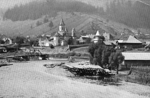
Description of Jakobeny
The Golden Bistritz rises in the 1931 m high Bila massif, from whose sand was panned for gold, mostly by gypsies, until the middle of the last century. As a wild, raging river, it covers the first stretch between steep mountain slopes through primeval forests, reaches Bukovina near Kirlibaba and, after another 20 kilometers, the 900 m high mining settlement Jakobeny. In contrast to the uninterrupted mountain range on the right side of the valley, which culminates in the 1709 m high Suhardelul, the heights on the left are lower and allow a transition to the neighboring Vltava valley with the 1096 m high Mestekaneschter Pass.
The place was characterized by the log cabin style of the residents as well as by Manz’s facilities for ore mining, blast furnaces, foundries and mine management. In addition, an evangelical, a Catholic, an Orthodox church and the Jewish temple emerged from religious freedom. The sawmill, the cultural center “Deutsches Haus” and the sulfur baths in Pucios are to be mentioned as other striking buildings. Coming upriver from Dorna-Watra, the Kaiserstraße (Emperor Franz II is said to have ridden through here) reaches Jakobeny, from here to cross the pass to Kimpolung into the Vltava valley. A railway line for the transport of wood and iron ore was built early on. In Jakobeny a large river weir was built from tree trunks and gravel fillers in the Bistritz,
The resettlement
The German Reich and the USSR demarcated their spheres of interest in Eastern Europe in the non-aggression pact of August 23, 1939, whereupon the German population outside the German area of interest (Baltic States and Galicia) was resettled in the Reich. With the completion of this resettlement, in June 1940 the USSR finally asked Romania to cede her Bessarabia and northern Bukovina. The German Empire advised Romania to give in and negotiated with Russia the resettlement of the German population. During the course of this resettlement, the German Reich negotiated a treaty with Romania on October 22nd, 1940 that the German population of southern Bukovina, North Dobruja, Moldavia and Wallachia could join the resettlement.
While the USSR had forced the complete departure of the German population, the resettlement of the German population of the Romanian areas was voluntary. Since the Romanian government was more generous than the Soviet in the details of the move, the majority of the population decided after initial hesitation.
With six rail transports from Jakobeni and four transports from Dorna (111 rail transports for the whole of South Bukovina) of 500 people each, the German population was transported via Radauz, Klagenfurt, Budapest to Graz, Leoben and Bruck an der Mur in Austria. The resettlement was completed in mid-December 1940.
The following Gotsch families left their homeland.
Lower Fuhrmannsgase: Gotsch Franz, Gotsch Michael, Gotsch Franz
Upper Fuhrmannsgasse: Gotsch Karl
Kaiserstraße: Gotsch Karl and Theresia, Gotsch Gottfried and Johanna
Die Czotina (alley): Gotsch Karolina (Kollegas)?
Upper Manzental: Gotsch Fritz, Gotsch Karl
The following Wagner families relocated :
Obere Fuhrmannsgasse: Wagner Jakob, Wagner Kathi, Wagner Franz
Am Klopatsch: Wagner Karl and Rosa
Unteres Manzental: Wagner Karl
The following Schneider families
relocated : Putschoß: Schneider Ludwig
Kaiserstraße: Schneider Gottlieb
Im Eisental: Schneider Rudolf Stefanie
The route through many stations
The transport to Austria was only the first stop on a long journey that was to lead through all of Germany. Again and again during the war there was a move from one camp to the next. Arrived towards the end of the war in Silesia or what is now Slovenia, when the Wehrmacht withdrew, they were relocated to Austria again. After the war, the rest of the odyssey shifted to West Germany, where the families, which had been separated in the meantime, finally found a new home – sometimes after 15 years.
The path of my grandparents Karl and Theresia Gotsch:
1941: Graz, Leipzig, Krummenhennersdorf, Rodewisch
1942: Bautzen, Dzieditz, Andrichau
1945: Gmunden
1948: Schalding, Weinsberg
1950: Backnang, Ludwigsburg
1954: Tamm
References
Erich Beck: Bukowina, land between Orient and Occident
Hauser / Herberth: Jakobeni and Kirlibaba, volumes 1 and 2